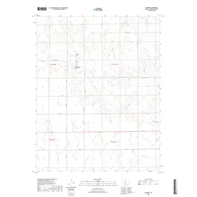
2018 Map of Wilmore
USGS Topo · Published 2018About this map
Wilmore serves as the central hub of this Comanche County landscape, situated at the intersection of Main St and Taft St. The town center includes a Po and is flanked to the north by the Powell Township Cem. This map illustrates a region defined by its complex drainage network, where Mule Cr winds past the northern edge of the settlement while several branches of the Nescatunga Cr and E Br Nescatunga Cr carve through the southern plains. The topography reveals significant local features like Snooks Hollow and Baker Canyon, which provide distinct contrast to the surrounding section lines. A network of rural roads, including Sun City Rd and Dirt Wilmore Rd, connects the scattered farmsteads across this agricultural territory.
Find a feature on this map
34 named features on this map. Tap any name to fly to it.
Don’t see what you’re looking for? This feature index may not catch every label — zoom into the map to look around manually.
Map Details
Editions of this 2018 Wilmore Map
This is the sole edition of this map. No revisions or reprints were ever made.
Other maps of this area

1892 · Coldwater
USGS Topo · 1:125,000

1955 · Pratt
USGS Topo · 1:250,000

1959 · Pratt
USGS Topo · 1:250,000

1968 · Wilmore SE
USGS Topo · 1:24,000

1968 · Belvidere
USGS Topo · 1:24,000

1979 · Coldwater
USGS Topo · 1:24,000

1979 · Protection NE
USGS Topo · 1:24,000
1980 · Nescatunga Creek North
USGS Topo · 1:24,000
1980 · Wilmore
USGS Topo · 1:24,000
1980 · Coldwater NE
USGS Topo · 1:24,000