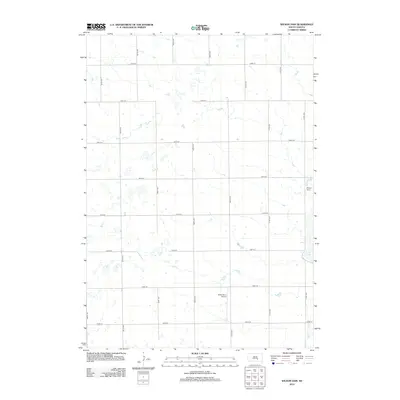
2012 Map of Wilson Dam
USGS Topo · Published 2012About this map
The agrarian landscape of Aurora County is defined here by a precise grid of rural roads and scattered prairie wetlands. In the northeast corner, Wilson Dam regulates local waters, creating a small reservoir that transitions into the northern reaches of White Lake. This 2012 survey illustrates the enduring structure of the Section Land System, with numeric routes such as 244th St and 367th Ave providing the primary framework for the township's agricultural activity. A notable modern addition to the traditional farm landscape is the Drake Farm Airport, a private airstrip situated in the southern portion of the quadrangle. The map is a study in South Dakota's open-country drainage patterns, where small, ephemeral ponds are interspersed between the straight lines of the county road system.
Find a feature on this map
18 named features on this map. Tap any name to fly to it.
Don’t see what you’re looking for? This feature index may not catch every label — zoom into the map to look around manually.
Map Details
Editions of this 2012 Wilson Dam Map
This is the sole edition of this map. No revisions or reprints were ever made.
Other maps of this area

1941 · Kimball North
USGS Topo · 1:62,500

1942 · Crow Lake
USGS Topo · 1:62,500

1951 · Kimball North
USGS Topo · 1:62,500

1955 · Mitchell
USGS Topo · 1:250,000

1959 · Mitchell
USGS Topo · 1:250,000

1979 · White Lake
USGS Topo · 1:24,000

1979 · Platte Lake
USGS Topo · 1:24,000

1979 · Kimball South
USGS Topo · 1:24,000
1982 · Wilmarth Lake
USGS Topo · 1:25,000
1982 · Kimball North
USGS Topo · 1:25,000
Featured Places
- Patten Township, SD
- White Lake Township, SD
- Lake Township, SD
- Willow Lake Township, SD
- Plainfield Township, SD