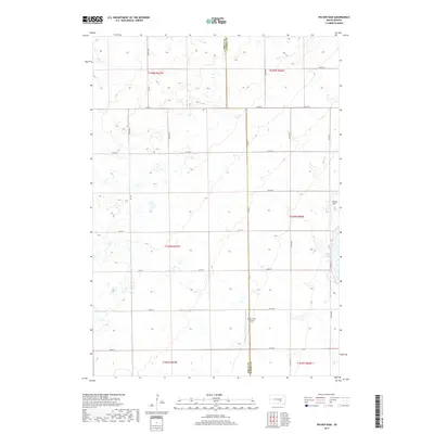
2017 Map of Wilson Dam
USGS Topo · Published 2017About this map
White Lake and the eastern edge of the South Dakota prairie define this landscape in Aurora County. The terrain is a complex arrangement of wetlands and small water bodies characteristic of the Missouri Coteau region, where natural drainage patterns intersect with the rigid grid of the Public Land Survey System. The map documents the rural infrastructure of the early 21st century, anchored by the Drake Farm Airport and the Wilson Dam near the eastern boundary. The north-south line of Brule Co Aurora Co serves as a primary jurisdictional marker, while the section lines are traced by a dense network of local routes such as Co Rd 24 and 372nd Ave. This survey captures the specialized land use of the High Plains, where agricultural tracts are punctuated by specific aviation and water management features.
Find a feature on this map
29 named features on this map. Tap any name to fly to it.
Don’t see what you’re looking for? This feature index may not catch every label — zoom into the map to look around manually.
Map Details
Editions of this 2017 Wilson Dam Map
This is the sole edition of this map. No revisions or reprints were ever made.
Other maps of this area

1941 · Kimball North
USGS Topo · 1:62,500

1942 · Crow Lake
USGS Topo · 1:62,500

1951 · Kimball North
USGS Topo · 1:62,500

1955 · Mitchell
USGS Topo · 1:250,000

1959 · Mitchell
USGS Topo · 1:250,000

1979 · White Lake
USGS Topo · 1:24,000

1979 · Platte Lake
USGS Topo · 1:24,000

1979 · Kimball South
USGS Topo · 1:24,000
1982 · Wilmarth Lake
USGS Topo · 1:25,000
1982 · Kimball North
USGS Topo · 1:25,000
Featured Places
- Patten Township, SD
- White Lake Township, SD
- Lake Township, SD
- Willow Lake Township, SD
- Plainfield Township, SD