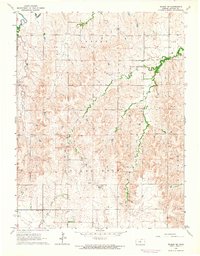
1964 Map of Wilson NE
USGS Topo · Published 1964About this map
Vesper and the surrounding Golden Belt Valley characterize this mid-1960s landscape in Lincoln County, Kansas. The terrain is deeply carved by water, with the Saline River winding through the northern portion while Bullfoot Creek, East Twin Creek, and Cow Creek drain the surrounding heights. Evidence of local community life is visible in the placement of the Church of Christ and educational landmarks like Margaret Sch. The map records several small-scale extractive operations, including various Quarries and a Gravel Pit scattered across the valley slopes, indicating the local economy's reliance on the land's geological resources. Genealogists will find particular value in the precisely located Emanuels Cem and Voss Cem, which serve as permanent markers of the area's early settler families within this agricultural region.
Find a feature on this map
14 named features on this map. Tap any name to fly to it.
Don’t see what you’re looking for? This feature index may not catch every label — zoom into the map to look around manually.
Map Details
Editions of this 1964 Wilson NE Map
This is the sole edition of this map. No revisions or reprints were ever made.
Other maps of this area

1894 · Ellsworth
USGS Topo · 1:125,000

1894 · Beloit
USGS Topo · 1:125,000

1955 · Great Bend
USGS Topo · 1:250,000

1955 · Beloit
USGS Topo · 1:250,000

1956 · Wilson
USGS Topo · 1:24,000

1957 · Great Bend
USGS Topo · 1:250,000

1957 · Westfall SW
USGS Topo · 1:24,000

1957 · Black Wolf
USGS Topo · 1:24,000

1958 · Great Bend
USGS Topo · 1:250,000

1959 · Beloit
USGS Topo · 1:250,000