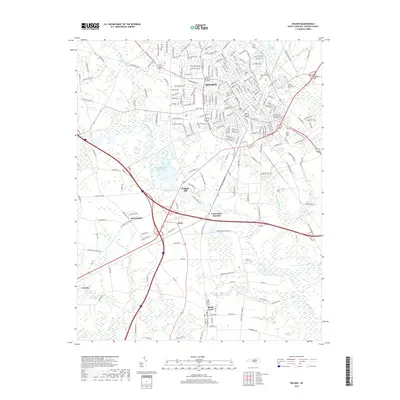
2019 Map of Wilson
USGS Topo · Published 2019About this map
Wilson serves as the primary hub of this eastern North Carolina landscape, where urban development meets a complex network of waterways and reservoirs. The city’s core is marked by institutional landmarks such as Barton Coll and the Wilson Community Coll, with historic burial grounds like Maplewood Cem and Rest Haven Cem situated near the city limits. The surrounding terrain is defined by the winding course of Contentnea Creek and its many tributaries, including Hominy Swamp and Toisnot Swamp. South of the main city, smaller nodes like Lucama, Black Creek, and the settlement at Dixie illustrate the traditional rural-to-urban transition of the region. Water management is a visible priority, evidenced by the Wiggins Mill Reservoir and Toisnot Reservoir, which anchor the local drainage system.
Find a feature on this map
211 named features on this map. Tap any name to fly to it.
Don’t see what you’re looking for? This feature index may not catch every label — zoom into the map to look around manually.
Map Details
Editions of this 2019 Wilson Map
This is the sole edition of this map. No revisions or reprints were ever made.
Other maps of this area

1902 · Kenly
USGS Topo · 1:62,500

1902 · Rocky Mount
USGS Topo · 1:62,500

1902 · Spring Hope
USGS Topo · 1:62,500

1903 · Kenly
USGS Topo · 1:62,500

1904 · Rocky Mount
USGS Topo · 1:62,500

1904 · Springhope
USGS Topo · 1:62,500

1904 · Wilson
USGS Topo · 1:62,500

1953 · Rocky Mount
USGS Topo · 1:250,000

1953 · Raleigh
USGS Topo · 1:250,000

1954 · Rocky Mount
USGS Topo · 1:250,000