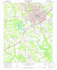
1978 Map of Wilson
USGS Topo · Published 1979About this map
Wilson serves as the focal point of this late 1970s survey, showing a well-established urban center surrounded by agricultural lands and small communities like Black Creek and Boswellville. The landscape is defined by the intersection of the Norfolk Southern and Seaboard Coast Line railroads, which historically shaped the region's tobacco and industrial economy. Significant institutional footprints are visible, including Atlantic Christian College and the Eastern NC Sch for Deaf, alongside civic anchors such as the Court House and County Hospital.
Find a feature on this map
49 named features on this map. Tap any name to fly to it.
Don’t see what you’re looking for? This feature index may not catch every label — zoom into the map to look around manually.
Map Details
Editions of this 1978 Wilson Map
This is the sole edition of this map. No revisions or reprints were ever made.
Other maps of this area

1902 · Kenly
USGS Topo · 1:62,500

1902 · Rocky Mount
USGS Topo · 1:62,500

1902 · Spring Hope
USGS Topo · 1:62,500

1903 · Kenly
USGS Topo · 1:62,500

1904 · Rocky Mount
USGS Topo · 1:62,500

1904 · Springhope
USGS Topo · 1:62,500

1904 · Wilson
USGS Topo · 1:62,500

1953 · Rocky Mount
USGS Topo · 1:250,000

1953 · Raleigh
USGS Topo · 1:250,000

1954 · Rocky Mount
USGS Topo · 1:250,000