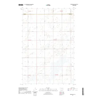
2018 Map of Wimbledon NE
USGS Topo · Published 2018About this map
The boundary between Griggs Co and Barnes Co defines the northern edge of this North Dakota landscape, where the survey lines of the Public Land Survey System have shaped the modern road network. This rural section of the plains is characterized by a precise grid of gravel and dirt roads, including 101st Ave SE and 105th Ave SE, which segment the terrain into square-mile sections. The map reveals the hydrology of the prairie pothole region, with numerous unnamed wetlands and depressions scattered across townships T143N R61W and T143N R60W. This topography illustrates the agricultural structure of the late 2010s, where movement is dictated by local connectors like 12th St SE and 18th St SE, serving isolated farmsteads and rural residents in a remote corner of the Red River Valley hinterlands.
Find a feature on this map
21 named features on this map. Tap any name to fly to it.
Don’t see what you’re looking for? This feature index may not catch every label — zoom into the map to look around manually.
Map Details
Editions of this 2018 Wimbledon NE Map
This is the sole edition of this map. No revisions or reprints were ever made.
Other maps of this area

1952 · New Rockford
USGS Topo · 1:250,000

1956 · New Rockford
USGS Topo · 1:250,000

1961 · Leal
USGS Topo · 1:24,000

1961 · Revere
USGS Topo · 1:24,000

1961 · Wimbledon
USGS Topo · 1:24,000

1961 · Hannaford
USGS Topo · 1:24,000

1961 · Wimbledon NE
USGS Topo · 1:24,000

1961 · Rogers
USGS Topo · 1:24,000
1961 · Sutton SW
USGS Topo · 1:24,000

1961 · Dazey
USGS Topo · 1:24,000