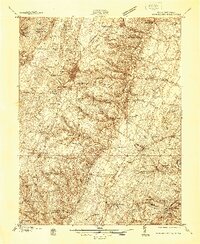
1938 Map of Winchester
USGS Topo · Published 1938About this map
Winchester serves as the focal point of this late-1930s survey, showing a landscape shaped by both deep colonial history and modernizing infrastructure. Defensive works like Star Fort and Fort Myer reflect the area's strategic importance during the Civil War, while the emerging Winchester Airport and the complex intersection of the Pennsylvania RR and Southern Ry point to its twentieth-century development. In the southern reaches, the historic estate of Greenway Court and the Blandy Experimental Farm (Univ of Va) mark the transition toward the Shenandoah River.
Find a feature on this map
105 named features on this map. Tap any name to fly to it.
Don’t see what you’re looking for? This feature index may not catch every label — zoom into the map to look around manually.
Map Details
Editions of this 1938 Winchester Map
This is the sole edition of this map. No revisions or reprints were ever made.
Other maps of this area

1884 · Harpers Ferry
USGS Topo · 1:125,000

1891 · Harpers Ferry
USGS Topo · 1:125,000

1893 · Luray
USGS Topo · 1:125,000

1893 · Harpers Ferry
USGS Topo · 1:125,000

1894 · Warrenton
USGS Topo · 1:125,000

1894 · Winchester
USGS Topo · 1:125,000

1905 · Luray
USGS Topo · 1:125,000

1914 · Martinsburg
USGS Topo · 1:48,000
1914 · Gerrardstown
USGS Topo · 1:48,000
1916 · Gerrardstown
USGS Topo · 1:62,500