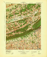
1943 Map of Wind Gap
USGS Topo · Published 1943About this map
Blue Mountain forms a formidable geological divide in this mid-century survey, separating the valley settlements of Northampton County from the rising Pocono Mountains to the north. The landscape is defined by a dense network of rural schoolhouses and family-named landmarks, such as Buskirk Sch and Jackson Sch, reflecting the decentralized community structure of the Pennsylvania countryside before widespread school consolidation. Industrial activity is concentrated at the Chapman Quarries and along the tracks of the Lehigh and New England railroad, which threads through the namesake Wind Gap pass. This gap serves as a critical transit corridor, connecting Saylorsburg with Pen Argyl. To the west, the winding Aquashicola Creek and Pohopoco Creek drain the terrain near Kresgeville and Kunkletown, illustrating the complex drainage patterns that shaped early regional road placement and village development.
Find a feature on this map
67 named features on this map. Tap any name to fly to it.
Don’t see what you’re looking for? This feature index may not catch every label — zoom into the map to look around manually.
Map Details
Editions of this 1943 Wind Gap Map
This is the sole edition of this map. No revisions or reprints were ever made.
Other maps of this area

1890 · Easton
USGS Topo · 1:62,500

1891 · Easton
USGS Topo · 1:62,500

1891 · Delaware Water Gap
USGS Topo · 1:62,500

1893 · Delaware Water Gap
USGS Topo · 1:62,500

1894 · Allentown
USGS Topo · 1:62,500

1902 · Slatington
USGS Topo · 1:62,500

1914 · Wind Gap
USGS Topo · 1:62,500

1916 · Wind Gap
USGS Topo · 1:62,500

1919 · Pocono
USGS Topo · 1:62,500

1921 · Pocono
USGS Topo · 1:62,500