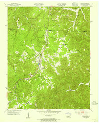
1953 Map of Winfield
USGS Topo · Published 1954About this map
Winfield and its neighbors straddle the state line between Tennessee and Kentucky in the early 1950s, a landscape defined by the Southern railroad and the heavily dissected ridges of the Cumberland National Forest. The map captures a high density of small rural institutions, including Emby King Sch and numerous country churches like Highway Ch and Piney Grove Ch. The presence of several Strip Mines in the northern section near Strunk indicates the localized extraction of coal and timber that fueled the regional economy. Family history is well-preserved through detailed naming of cemeteries such as Chitwood Cem, Ryan Cem, and Isham Cem, alongside creek systems like Roaring Paunch Creek and Jettico Creek that carved the deep valleys of Honeycutt Mountain.
Find a feature on this map
41 named features on this map. Tap any name to fly to it.
Don’t see what you’re looking for? This feature index may not catch every label — zoom into the map to look around manually.
Map Details
Editions of this 1953 Winfield Map
2 editions found
Other maps of this area

1890 · Williamsburg
USGS Topo · 1:125,000

1893 · Briceville
USGS Topo · 1:125,000

1894 · Williamsburg
USGS Topo · 1:125,000

1895 · Wartburg
USGS Topo · 1:125,000

1895 · Briceville
USGS Topo · 1:125,000

1896 · Wartburg
USGS Topo · 1:125,000

1896 · Briceville
USGS Topo · 1:125,000

1934 · Barthell
USGS Topo · 1:62,500

1936 · Pioneer
USGS Topo · 1:24,000
1946 · Pioneer
USGS Topo · 1:24,000