Loading...
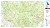
Loading map...1986 Map of Winnfield
USGS Topo · Published 1988About this map
Winnfield serves as a central hub in this mid-1980s look at Central Louisiana, where the timber and rail industries define the landscape. The Kansas City Southern Railroad and Missouri Pacific Railroad intersect near the town, connecting it to smaller logging and railroad communities like Urania, Tullos, and Olla. The vast wetlands of the Kisatchie National Forest are punctuated by significant water bodies, including the wide Iatt Lake and the northern reaches of Catahoula Lake.
Find a feature on this map
109 named features on this map. Tap any name to fly to it.
Don’t see what you’re looking for? This feature index may not catch every label — zoom into the map to look around manually.
Map Details
Date Portrayed1986
Date Published1988
PublisherU.S. Geological Survey
Map TypeTopographic
Scale1:100,000
Physical Dimensions43.5 x 24.1 inches
Editions of this 1986 Winnfield Map
2 editions found

Historical Maps of Winnfield Through Time
Featured Locations
Source Details
SourceU.S. Geological Survey
CopyrightPublic Domain