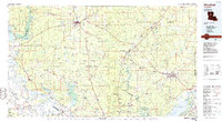
1986 Map of Winnfield
USGS Topo · Published 1986About this map
The Kisatchie Hills and the sprawling drainages of the Dugdemona River and Little River define this mid-1980s landscape across Central Louisiana. The area is characterized by a dense network of small timber and rail settlements like Packton, Zenoria, and Good Pine, many of which were founded around the local lumber industry. In the eastern portion, the terrain transitions into the lowlands of the Catahoula National Wildlife Refuge, where the massive Catahoula Lake dominates the horizon.
Find a feature on this map
140 named features on this map. Tap any name to fly to it.
Don’t see what you’re looking for? This feature index may not catch every label — zoom into the map to look around manually.
Map Details
Editions of this 1986 Winnfield Map
2 editions found
Other maps of this area

1932 · Colfax NE
USGS Topo · 1:31,680

1932 · Boyce NE
USGS Topo · 1:31,680

1932 · Colfax SW
USGS Topo · 1:31,680

1932 · Colfax SE
USGS Topo · 1:31,680

1932 · Colfax NW
USGS Topo · 1:31,680

1935 · Verda
USGS Topo · 1:31,680

1935 · Tooleys
USGS Topo · 1:62,500

1936 · Colfax
USGS Topo · 1:62,500

1936 · Pollock
USGS Topo · 1:62,500

1937 · Campti NE
USGS Topo · 1:31,680