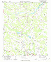
1977 Map of Winstead Crossroads
USGS Topo · Published 1977About this map
Winstead Crossroads serves as a central landmark in this mid-1970s survey of the borderlands between Nash and Wilson counties. The Tar River meanders across the northern section, crossed by the Cockrell Bridge and monitored by a gaging station, while the southern portion transition into the suburban fringes of Wilson. Educational and religious institutions anchor the rural communities, including the Tar River Sch and numerous country churches such as Sandy Fork Ch and Mt Hermon Ch.
Find a feature on this map
45 named features on this map. Tap any name to fly to it.
Don’t see what you’re looking for? This feature index may not catch every label — zoom into the map to look around manually.
Map Details
Editions of this 1977 Winstead Crossroads Map
This is the sole edition of this map. No revisions or reprints were ever made.
Other maps of this area

1902 · Kenly
USGS Topo · 1:62,500

1902 · Rocky Mount
USGS Topo · 1:62,500

1902 · Spring Hope
USGS Topo · 1:62,500

1903 · Kenly
USGS Topo · 1:62,500

1904 · Rocky Mount
USGS Topo · 1:62,500

1904 · Springhope
USGS Topo · 1:62,500

1904 · Wilson
USGS Topo · 1:62,500

1953 · Rocky Mount
USGS Topo · 1:250,000

1953 · Raleigh
USGS Topo · 1:250,000

1954 · Rocky Mount
USGS Topo · 1:250,000