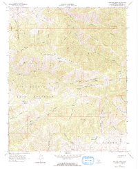
1966 Map of Winters Ridge
USGS Topo · Published 1967About this map
Winters Ridge and Middle Ridge dominate this mid-century landscape in the Tehachapi Mountains, where the land is defined by deep canyons and an intricate network of named water sources. The map captures a transitional territory between the Los Alamos Y Agua Caliente and La Liebre land grants, showing a rugged terrain largely accessible only via the Tejon Trail or various jeep trails. For the researcher, the map preserves the exact locations of numerous remote springs and canyons that were vital for cattle and early ranching, such as Cow Chip Spring, Urcado Springs, and Pastoria Spring. The lack of formal townsites highlights the area's isolation, punctuated only by occasional infrastructure like a isolated Radio Facility and scattered water tanks along the drainages of Tunis Creek and El Paso Creek.
Find a feature on this map
49 named features on this map. Tap any name to fly to it.
Don’t see what you’re looking for? This feature index may not catch every label — zoom into the map to look around manually.
Map Details
Editions of this 1966 Winters Ridge Map
2 editions found
Other maps of this area

1903 · Tejon
USGS Topo · 1:125,000

1914 · Caliente
USGS Topo · 1:125,000

1931 · Tejon Hills
USGS Topo · 1:31,680

1933 · Tejon Hills
USGS Topo · 1:31,680

1943 · Cummings Mountain
USGS Topo · 1:62,500

1943 · Neenach
USGS Topo · 1:62,500
1945 · Pastoria Creek
USGS Topo · 1:31,680
1945 · Lebec
USGS Topo · 1:31,680

1948 · Bakersfield
USGS Topo · 1:250,000

1949 · Los Angeles
USGS Topo · 1:250,000