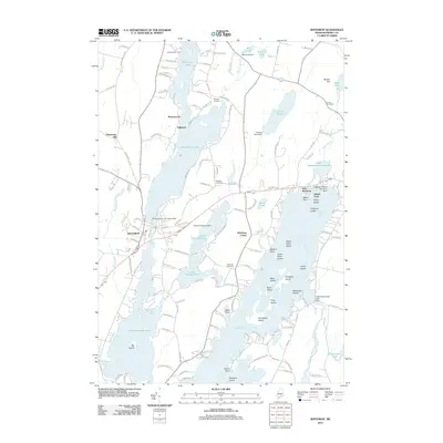
2011 Map of Winthrop
USGS Topo · Published 2011About this map
Winthrop serves as the hub of a landscape defined by its interconnected waterways, where the village center sits between the shores of Annabessacook Lake and Maranacook Lake. By the early 21st century, the area’s identity remained deeply tied to its glacial lake system, evidenced by specialized infrastructure like the Fowler Seaplane Base on Upper Narrows Pond and the Lakeside Marina Seaplane Base near East Winthrop. The map reveals a high density of seasonal and year-round residential development along the shorelines of Cobbosseecontee Lake, with numerous named islands such as Hodgdon Island and Horseshoe Island. Genealogists will find several burial grounds across the township, including Lakeview Cemetery and the more secluded Whittier Cemetery near Maranacook. The presence of several dams, such as the Maranacook Lake Upper Dam and Carleton Pond Dam, indicates the long-standing management of these waters for local utility and recreation.
Find a feature on this map
142 named features on this map. Tap any name to fly to it.
Don’t see what you’re looking for? This feature index may not catch every label — zoom into the map to look around manually.
Map Details
Editions of this 2011 Winthrop Map
This is the sole edition of this map. No revisions or reprints were ever made.
Other maps of this area

1892 · Gardiner
USGS Topo · 1:62,500

1892 · Augusta
USGS Topo · 1:62,500

1908 · Lewiston
USGS Topo · 1:62,500

1910 · Livermore
USGS Topo · 1:62,500

1912 · Livermore
USGS Topo · 1:62,500

1941 · Livermore
USGS Topo · 1:62,500

1941 · Augusta
USGS Topo · 1:62,500

1942 · Lewiston
USGS Topo · 1:62,500

1943 · Augusta
USGS Topo · 1:62,500

1943 · Gardiner
USGS Topo · 1:62,500