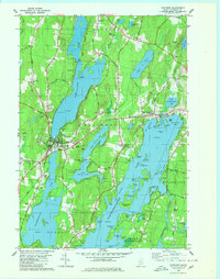
1980 Map of Winthrop
USGS Topo · Published 1980About this map
Winthrop and its surrounding water bodies serve as the focal point of this 1980 survey, illustrating a landscape defined by glacial lakes and early transportation routes. The Maine Central railroad corridor tracks along the western shore of Maranacook Lake, passing through Maranacook and Tallwood before reaching the village center. This area is characterized by its complex hydrology, with the narrow divides between Upper Narrows Pond and Lower Narrows Pond situated just east of the main town.
Find a feature on this map
99 named features on this map. Tap any name to fly to it.
Don’t see what you’re looking for? This feature index may not catch every label — zoom into the map to look around manually.
Map Details
Editions of this 1980 Winthrop Map
This is the sole edition of this map. No revisions or reprints were ever made.
Other maps of this area

1892 · Gardiner
USGS Topo · 1:62,500

1892 · Augusta
USGS Topo · 1:62,500

1908 · Lewiston
USGS Topo · 1:62,500

1910 · Livermore
USGS Topo · 1:62,500

1912 · Livermore
USGS Topo · 1:62,500

1941 · Livermore
USGS Topo · 1:62,500

1941 · Augusta
USGS Topo · 1:62,500

1942 · Lewiston
USGS Topo · 1:62,500

1943 · Augusta
USGS Topo · 1:62,500

1943 · Gardiner
USGS Topo · 1:62,500