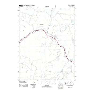
2011 Map of Wolcott
USGS Topo · Published 2011About this map
The Eagle River carves a deep path through Eagle County, serving as the primary corridor for transportation and settlement in this portion of the Colorado Rockies. Near the river's bend, the community of Wolcott is situated at a strategic junction of mountain roads, while to the south, the settlement of Carterville is found near the head of Stag Gulch. The landscape is dominated by high-elevation features such as Bocco Mountain and Bellyache Ridge, with the latter marked by a network of winding residential roads including Bellyache Ridge Rd.
Find a feature on this map
53 named features on this map. Tap any name to fly to it.
Don’t see what you’re looking for? This feature index may not catch every label — zoom into the map to look around manually.
Map Details
Editions of this 2011 Wolcott Map
This is the sole edition of this map. No revisions or reprints were ever made.
Other maps of this area

1957 · Leadville
USGS Topo · 1:250,000

1959 · Leadville
USGS Topo · 1:250,000

1960 · Leadville
USGS Topo · 1:250,000

1962 · Leadville
USGS Topo · 1:250,000

1962 · Grouse Mountain
USGS Topo · 1:24,000

1962 · Fulford
USGS Topo · 1:24,000

1962 · Wolcott
USGS Topo · 1:24,000

1962 · Eagle
USGS Topo · 1:24,000

1962 · Edwards
USGS Topo · 1:24,000
1962 · The Seven Hermits
USGS Topo · 1:24,000