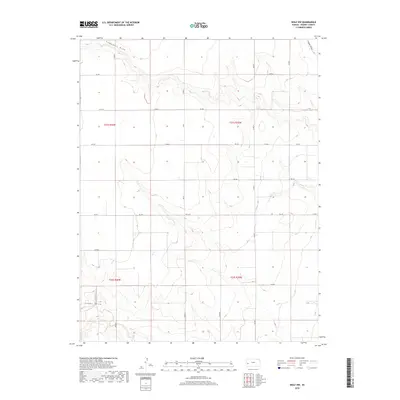
2018 Map of Wolf NW
USGS Topo · Published 2018About this map
Campbell Draw and Crozier Draw carve through the north-central plains of Kearny County, defining a landscape shaped by intermittent drainage and the Public Land Survey System. The map reveals a strictly regulated grid of section lines and county roads, reflecting the systematic agricultural development of western Kansas in the early 21st century. James Draw cuts through the southwestern corner, adding topographic variety to an otherwise flat terrain primarily accessed by a network of rural routes. These corridors, including Co Rd 7 and the secondary highway Fas 1523, are the lifelines of the local economy, connecting scattered farmsteads and ranching operations across the townships. The precision of the 2018 survey captures the exact alignment of these local roads as they negotiate the gentle draws and level uplands of the High Plains.
Find a feature on this map
24 named features on this map. Tap any name to fly to it.
Don’t see what you’re looking for? This feature index may not catch every label — zoom into the map to look around manually.
Map Details
Editions of this 2018 Wolf NW Map
This is the sole edition of this map. No revisions or reprints were ever made.
Other maps of this area

1941 · Modoc
USGS Topo · 1:62,500

1951 · Modoc
USGS Topo · 1:62,500

1955 · Scott City
USGS Topo · 1:250,000

1958 · Scott City
USGS Topo · 1:250,000
1965 · Wolf
USGS Topo · 1:24,000

1965 · Leoti 3 NE
USGS Topo · 1:24,000

1965 · Wolf NW
USGS Topo · 1:24,000

1965 · Wolf NE
USGS Topo · 1:24,000
1966 · Wolf SW
USGS Topo · 1:24,000
1966 · Leoti 3 SE
USGS Topo · 1:24,000