
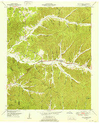
1936 Map of Wolf Pit Ridge
USGS Topo · Published 1936About this map
Wolf Pit Ridge dominates the high ground in this 1936 survey of Hardin County, where a network of trails and unimproved roads connects isolated farmsteads and rural institutions. The southern portion of the sheet is centered on the community of Gillises Mills, supported by the local Gillis Sch and Gillis Cem. Education and faith were clearly central to life in these hollows, as evidenced by the Center Star Sch and Union Chapel Sch located along the winding valley routes.
Find a feature on this map
76 named features on this map. Tap any name to fly to it.
Don’t see what you’re looking for? This feature index may not catch every label — zoom into the map to look around manually.
Map Details
Editions of this 1936 Wolf Pit Ridge Map
This is the sole edition of this map. No revisions or reprints were ever made.
Other maps of this area

1905 · Waynesboro
USGS Topo · 1:125,000

1936 · Savannah
USGS Topo · 1:24,000

1936 · Hookers Bend
USGS Topo · 1:24,000

1936 · Eagle Creek
USGS Topo · 1:24,000

1936 · Olivehill
USGS Topo · 1:24,000

1936 · Pickwick
USGS Topo · 1:24,000

1936 · Ransom Stand
USGS Topo · 1:24,000

1936 · Lowryville
USGS Topo · 1:24,000

1936 · Martins Mills
USGS Topo · 1:24,000
1949 · Eagle Creek
USGS Topo · 1:24,000