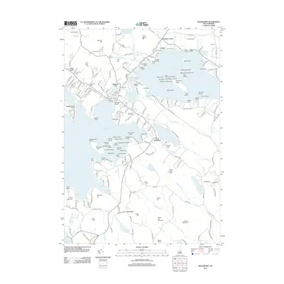
2012 Map of Wolfeboro
USGS Topo · Published 2012About this map
The eastern shores of Lake Winnipesaukee meet the resort and residential developments of Carroll County in the early 21st century. Wolfeboro remains the central hub, characterized by its dense network of streets and landmarks like the Wolfeboro Town Docks and Brewster Beach. The landscape transitions from the busy waterfront of Front Bay to the quieter elevations of Bennett Hill and Pine Hill. Local history is preserved in several burial grounds, including Pine Hill Cem and Lakeview Cem.
Find a feature on this map
225 named features on this map. Tap any name to fly to it.
Don’t see what you’re looking for? This feature index may not catch every label — zoom into the map to look around manually.
Map Details
Editions of this 2012 Wolfeboro Map
This is the sole edition of this map. No revisions or reprints were ever made.
Other maps of this area

1909 · Winnepesaukee
USGS Topo · 1:62,500

1919 · Gilmanton
USGS Topo · 1:62,500

1919 · Alton
USGS Topo · 1:62,500

1927 · Gilmanton
USGS Topo · 1:62,500

1928 · Wolfeboro
USGS Topo · 1:62,500

1949 · Portland
USGS Topo · 1:250,000

1956 · Winnipesaukee
USGS Topo · 1:62,500

1956 · Portland
USGS Topo · 1:250,000

1957 · Alton
USGS Topo · 1:62,500
1957 · Gilmanton
USGS Topo · 1:62,500