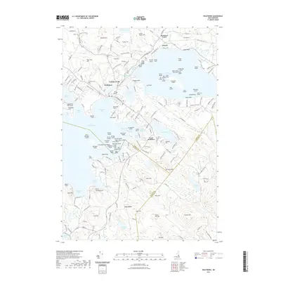
2021 Map of Wolfeboro
USGS Topo · Published 2021About this map
Wolfeboro sits at the heart of this lakes region landscape, where the waters of Lake Winnipesaukee meet the town's historic shoreline. The map illustrates a dense network of lakeside settlements, from the residential clusters at Wolfeboro Falls and South Wolfeboro to the outlying village of East Alton. This modern survey reveals how the former rail infrastructure has been repurposed, most notably with the Cotton Valley Rail Trl cutting through the center of the quadrangle near Crescent Lake. Local history and genealogy are anchored by several established burial grounds, including Pine Hill Cem and Lakeview Cem. The surrounding terrain is defined by numerous water bodies like Lake Wentworth and Rust Pond, while prominent elevations such as Pine Hill and Bennett Hill provide a high-ground contrast to the marshy lowlands of Ryefield Marsh.
Find a feature on this map
216 named features on this map. Tap any name to fly to it.
Don’t see what you’re looking for? This feature index may not catch every label — zoom into the map to look around manually.
Map Details
Editions of this 2021 Wolfeboro Map
This is the sole edition of this map. No revisions or reprints were ever made.
Other maps of this area

1909 · Winnepesaukee
USGS Topo · 1:62,500

1919 · Gilmanton
USGS Topo · 1:62,500

1919 · Alton
USGS Topo · 1:62,500

1927 · Gilmanton
USGS Topo · 1:62,500

1928 · Wolfeboro
USGS Topo · 1:62,500

1949 · Portland
USGS Topo · 1:250,000

1956 · Winnipesaukee
USGS Topo · 1:62,500

1956 · Portland
USGS Topo · 1:250,000

1957 · Alton
USGS Topo · 1:62,500
1957 · Gilmanton
USGS Topo · 1:62,500