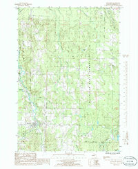
1986 Map of Wolverine
USGS Topo · Published 1986About this map
The Sturgeon River and its West Branch carve through the timbered landscapes of the Mackinaw State Forest in this mid-1980s topographical record. The village of Wolverine serves as the primary hub at the confluence of these waters, with smaller settlements like Rondo, Beebe, and Haakwood distributed along the northern and southern corridors. The industrial history of the region is etched into the terrain by an Old RR Grade, tracing a route that once supported the logging and transport economy of Cheboygan County. In the townships of Ellis and Nunda, the land is characterized by numerous small tributaries such as Johnson Creek and Crumley Creek. Local landmarks including a Lookout Tower and a Flowing Well point to the practical infrastructure of the era, while the Pigeon River marks the eastern boundary of this forested landscape.
Find a feature on this map
30 named features on this map. Tap any name to fly to it.
Don’t see what you’re looking for? This feature index may not catch every label — zoom into the map to look around manually.
Map Details
Editions of this 1986 Wolverine Map
This is the sole edition of this map. No revisions or reprints were ever made.
Other maps of this area

1954 · Gaylord
USGS Topo · 1:62,500

1954 · Hetherton
USGS Topo · 1:62,500

1955 · Cheboygan
USGS Topo · 1:250,000

1957 · Tower
USGS Topo · 1:62,500

1957 · Wolverine
USGS Topo · 1:62,500

1958 · Cheboygan
USGS Topo · 1:250,000

1982 · Petoskey
USGS Topo · 1:100,000
1986 · Legrand
USGS Topo · 1:24,000
1986 · Green Timbers
USGS Topo · 1:24,000
1986 · Wildwood
USGS Topo · 1:24,000