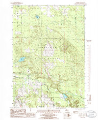
1986 Map of Legrand
USGS Topo · Published 1986About this map
Legrand serves as a central focal point in this 1980s-era study of the northern Lower Peninsula, situated where the Old RR Grade crosses the landscape near Morrow Creek. The terrain is defined by the dense woodlands of the Mackinaw State Forest and a complex hydrological network including Mullett Lake in the northwest corner and the converging branches of the North Branch Little Pigeon River. Small settlements such as Afton and Fingerboard Corner are connected by a grid of rural roads and timber trails, reflecting the area's history of forestry and transit. Local landmarks like the Town Hall and various Gravel Pits indicate the civic and industrial activity of the day. The presence of numerous family-named water bodies, such as Devereaux Lake and Silver Lake, highlights the importance of the region's inland waters for both local identity and the surrounding wilderness environment.
Find a feature on this map
22 named features on this map. Tap any name to fly to it.
Don’t see what you’re looking for? This feature index may not catch every label — zoom into the map to look around manually.
Map Details
Editions of this 1986 Legrand Map
This is the sole edition of this map. No revisions or reprints were ever made.
Other maps of this area

1955 · Cheboygan
USGS Topo · 1:250,000

1957 · Tower
USGS Topo · 1:62,500

1957 · Wolverine
USGS Topo · 1:62,500

1957 · Cheboygan
USGS Topo · 1:62,500

1957 · Mullett Lake
USGS Topo · 1:62,500

1958 · Cheboygan
USGS Topo · 1:250,000

1982 · Petoskey
USGS Topo · 1:100,000

1982 · Aloha
USGS Topo · 1:25,000
1982 · Mullett Lake
USGS Topo · 1:25,000
1982 · Manning
USGS Topo · 1:25,000