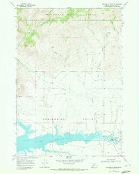
1968 Map of Wolverine Creek
USGS Topo · Published 1972About this map
Centennial Valley dominates the lower half of this landscape, where the Red Rock River flows into the expansive Lima Reservoir. The map illustrates a complex hydrological system feeding the basin from the north, including Clover Creek, Sandy Creek, and the multi-branched Wolverine Creek. To the north, the terrain rises into the Beaverhead National Forest, defined by high-elevation drainages like the East Fork Clover Creek. Cultural markings are sparse but significant, showing the ranching and resource infrastructure of late 1960s Beaverhead County. Local connectivity is represented by Price Lane and the crossing at Lyons Bridge, while a single Drill Hole near the creek suggests exploration of the subterranean geology. The survey also captures the controlled inundation area of the reservoir, marking the interface between the wild forest slopes and the managed water resources of the valley floor.
Find a feature on this map
17 named features on this map. Tap any name to fly to it.
Don’t see what you’re looking for? This feature index may not catch every label — zoom into the map to look around manually.
Map Details
Editions of this 1968 Wolverine Creek Map
This is the sole edition of this map. No revisions or reprints were ever made.
Other maps of this area

1955 · Dubois
USGS Topo · 1:250,000

1958 · Dubois
USGS Topo · 1:250,000

1968 · Stonehouse Mountain
USGS Topo · 1:24,000

1968 · Corral Creek
USGS Topo · 1:24,000

1968 · Big Table Mountain
USGS Topo · 1:24,000

1968 · Whiskey Spring
USGS Topo · 1:24,000

1968 · Lima Dam
USGS Topo · 1:24,000

1968 · Antelope Peak
USGS Topo · 1:24,000

1968 · Monida
USGS Topo · 1:24,000

1968 · Antone Peak
USGS Topo · 1:24,000