
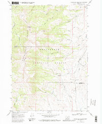
1968 Map of Stonehouse Mountain
USGS Topo · Published 1972About this map
The Snowcrest Range dominates this late-1960s landscape, providing a high-elevation divide between Madison and Beaverhead counties. The area is defined by its network of drainages feeding into the Ruby River, including Beaver Creek and the South Fork. Human presence is marked primarily by infrastructure for forest management and transit, notably the Divide Creek Guard Station situated near the Centennial Road.
Find a feature on this map
38 named features on this map. Tap any name to fly to it.
Don’t see what you’re looking for? This feature index may not catch every label — zoom into the map to look around manually.
Map Details
Editions of this 1968 Stonehouse Mountain Map
2 editions found
Other maps of this area

1950 · Lower Red Rock Lake
USGS Topo · 1:62,500

1950 · Monument Ridge
USGS Topo · 1:62,500

1955 · Dubois
USGS Topo · 1:250,000

1955 · Ashton
USGS Topo · 1:250,000

1958 · Dubois
USGS Topo · 1:250,000

1958 · Ashton
USGS Topo · 1:250,000

1960 · Ashton
USGS Topo · 1:250,000

1968 · Antelope Peak
USGS Topo · 1:24,000

1968 · Antone Peak
USGS Topo · 1:24,000
1968 · Swamp Creek
USGS Topo · 1:24,000