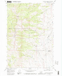
1968 Map of Stonehouse Mountain
USGS Topo · Published 1980About this map
Beaverhead National Forest land defines this portion of the Snowcrest Range along the boundary of Madison Co and Beaverhead Co. The high-elevation terrain is marked by distinctive basins and meadows, including Honeymoon Park and Peterson Basin. Transportation through this roadless interior relies on an established network of routes like the Snowcrest Trail and Gilbert Trail, which facilitate movement between peaks such as Stonehouse Mountain and Mount Carey. A primary point of administrative activity is the Divide Creek Guard Station, situated near the headwaters of numerous drainages. These waters, including Andy Dick Creek and the South Fork, flow into the Ruby River system. The geography of the Centennial Divide provides a natural demarcation in this remote section of the Montana Rockies.
Find a feature on this map
39 named features on this map. Tap any name to fly to it.
Don’t see what you’re looking for? This feature index may not catch every label — zoom into the map to look around manually.
Map Details
Editions of this 1968 Stonehouse Mountain Map
2 editions found
Other maps of this area

1950 · Lower Red Rock Lake
USGS Topo · 1:62,500

1950 · Monument Ridge
USGS Topo · 1:62,500

1955 · Dubois
USGS Topo · 1:250,000

1955 · Ashton
USGS Topo · 1:250,000

1958 · Dubois
USGS Topo · 1:250,000

1958 · Ashton
USGS Topo · 1:250,000

1960 · Ashton
USGS Topo · 1:250,000

1968 · Stonehouse Mountain
USGS Topo · 1:24,000

1968 · Antelope Peak
USGS Topo · 1:24,000

1968 · Antone Peak
USGS Topo · 1:24,000