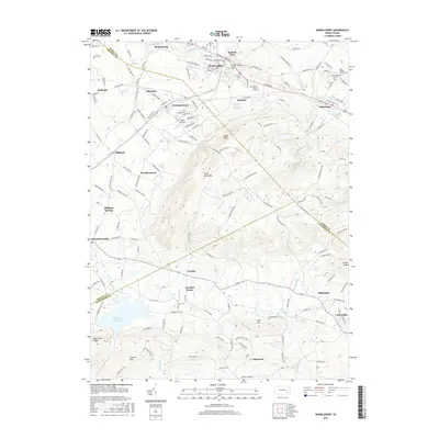
2016 Map of Womelsdorf
USGS Topo · Published 2016About this map
The Union Canal and Tulpehocken Creek trace the northern lowlands of this Berks County landscape, where the colonial-era legacy of the region is anchored by the Conrad Weiser Gravesite. The terrain transitions sharply from the agricultural valley floor near Womelsdorf and Stouchsburg into the prominent elevations of South Mountain and Eagle Peak. These ridges separate the northern settlements from the southern reaches of Lancaster County, where the Furnace Hills and Middle Cr Reservoir dominate the topography. Local genealogy is well-served by numerous burial sites, including Womelsdorf Union Cem and Saint Daniels Church Cem, alongside established communities such as Newmanstown, Robesonia, and Schoeneck. The map also details the specialized land use of the era, from the small Hurst Airport to the Bethany Childrens Home Spring, illustrating the persistent village-and-valley settlement pattern of Pennsylvania's Dutch Country.
Find a feature on this map
57 named features on this map. Tap any name to fly to it.
Don’t see what you’re looking for? This feature index may not catch every label — zoom into the map to look around manually.
Map Details
Editions of this 2016 Womelsdorf Map
This is the sole edition of this map. No revisions or reprints were ever made.
Other maps of this area

1891 · Lebanon
USGS Topo · 1:62,500

1893 · Lebanon
USGS Topo · 1:62,500

1899 · Lebanon
USGS Topo · 1:62,500

1902 · Wernersville
USGS Topo · 1:62,500

1902 · Lancaster
USGS Topo · 1:62,500

1904 · Lancaster
USGS Topo · 1:62,500

1906 · New Holland
USGS Topo · 1:62,500

1908 · New Holland
USGS Topo · 1:62,500

1941 · New Holland
USGS Topo · 1:62,500

1943 · Lancaster
USGS Topo · 1:62,500