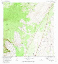
1981 Map of Wood Valley
USGS Topo · Published 1981About this map
The Southwest Rift Zone defines the volatile geography of this 1981 survey, where the terrestrial power of Kilauea is visible in the stark Great Crack and the Keamoku Lava Flow of 1823. In the eastern section, the Hawaii Volcanoes National Park boundary meets the high elevations of Kaoiki, while to the west, the Kapapala Forest Reserve blankets the slopes above the Wood Valley Homesteads. Human settlement persists in the shadow of these geological forces at the Kapapala Ranch and Wood Valley Camp, connected by historical routes like the Peter Lee Road and the Ainapo Trail. The map also documents essential water sources in this environment, such as the Pakon Waterhole and Kaopapawai Waterhole, alongside unique volcanic features like the Ponohohoa Chasms.
Find a feature on this map
48 named features on this map. Tap any name to fly to it.
Don’t see what you’re looking for? This feature index may not catch every label — zoom into the map to look around manually.
Map Details
Editions of this 1981 Wood Valley Map
2 editions found
Other maps of this area

1921 · Kilauea
USGS Topo · 1:62,500

1923 · Pahala
USGS Topo · 1:62,500

1924 · Kilauea
USGS Topo · 1:62,500

1924 · Honuapo
USGS Topo · 1:62,500

1928 · Mauna Loa
USGS Topo · 1:62,500

1954 · Hawaii South
USGS Topo · 1:250,000

1959 · Hawaii South
USGS Topo · 1:250,000

1961 · Hawaii South
USGS Topo · 1:250,000

1962 · Hawaii South
USGS Topo · 1:250,000
1963 · Kau Desert
USGS Topo · 1:24,000