
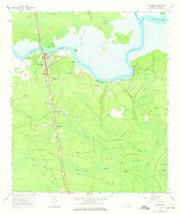
1958 Map of Woodbine
USGS Topo · Published 1959About this map
The Satilla River carves a deep meandering path across this coastal Georgia landscape, defining the northern edge of Woodbine and its surrounding wetlands. The town serves as a hub for the Seaboard Air Line Railroad, which runs a direct north-south corridor through the swampy terrain, passing through smaller communities like Colesburg and Seals. This mid-century environment is characterized by the tension between the industrial rail lines and the vast tidal influences of the Honey Swamp and Walker Swamp.
Find a feature on this map
55 named features on this map. Tap any name to fly to it.
Don’t see what you’re looking for? This feature index may not catch every label — zoom into the map to look around manually.
Map Details
Editions of this 1958 Woodbine Map
2 editions found
Other maps of this area

1917 · Nahunta
USGS Topo · 1:62,500

1917 · Boulogne
USGS Topo · 1:62,500

1918 · Nahunta
USGS Topo · 1:62,500

1918 · Bladen
USGS Topo · 1:62,500

1918 · Kingsland
USGS Topo · 1:62,500

1919 · Boulogne
USGS Topo · 1:62,500

1939 · Bladen
USGS Topo · 1:62,500

1946 · Brunswick
USGS Topo · 1:250,000

1948 · Jacksonville
USGS Topo · 1:250,000

1948 · Brunswick
USGS Topo · 1:250,000