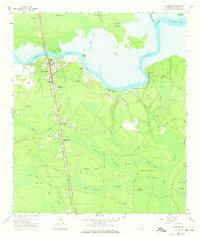
1958 Map of Woodbine
USGS Topo · Published 1974About this map
The Satilla River defines the northern reaches of this coastal Georgia landscape, winding past the town of Woodbine and several small riverside settlements like Halifax and Ceylon. The Seaboard Air Line Railroad runs a straight north-south course through the terrain, serving as a primary transportation artery for the town and nearby communities such as Colesburg and Seals. Low-lying wetlands and numerous named islands, including Grassy Island and New Hope Island, dominate the interior, illustrating the complex drainage patterns of Walker Swamp and New Hope Swamp.
Find a feature on this map
52 named features on this map. Tap any name to fly to it.
Don’t see what you’re looking for? This feature index may not catch every label — zoom into the map to look around manually.
Map Details
Editions of this 1958 Woodbine Map
2 editions found

Other maps of this area

1917 · Nahunta
USGS Topo · 1:62,500

1917 · Boulogne
USGS Topo · 1:62,500

1918 · Nahunta
USGS Topo · 1:62,500

1918 · Bladen
USGS Topo · 1:62,500

1918 · Kingsland
USGS Topo · 1:62,500

1919 · Boulogne
USGS Topo · 1:62,500

1939 · Bladen
USGS Topo · 1:62,500

1946 · Brunswick
USGS Topo · 1:250,000

1948 · Jacksonville
USGS Topo · 1:250,000

1948 · Brunswick
USGS Topo · 1:250,000