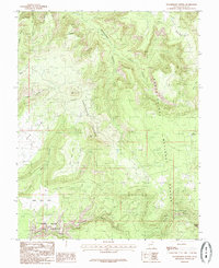
1985 Map of Woodenshoe Buttes
USGS Topo · Published 1985About this map
Woodenshoe Buttes dominate this high-desert plateau within the Manti-La Sal National Forest during the mid-1980s. The landscape is defined by its dramatic erosion patterns, where deep drainages like Woodenshoe Canyon and Cherry Canyon carve through the sedimentary layers. Anthropomorphic landmarks such as The Heel and The Toe stand alongside Piñon Point and Dry Mesa, providing a clear record of the area's geological character.
Find a feature on this map
20 named features on this map. Tap any name to fly to it.
Don’t see what you’re looking for? This feature index may not catch every label — zoom into the map to look around manually.
Map Details
Editions of this 1985 Woodenshoe Buttes Map
This is the sole edition of this map. No revisions or reprints were ever made.
Other maps of this area

1886 · Henry Mountains
USGS Topo · 1:250,000

1886 · Abajo
USGS Topo · 1:250,000

1892 · Abajo
USGS Topo · 1:250,000

1892 · Henry Mountains
USGS Topo · 1:250,000

1893 · Abajo
USGS Topo · 1:250,000

1935 · Elk Ridge
USGS Topo · 1:96,000

1940 · Elk Ridge
USGS Topo · 1:125,000

1952 · Mouth of Dark Canyon
USGS Topo · 1:62,500

1952 · Natural Bridges
USGS Topo · 1:62,500

1954 · White Canyon 4 NE
USGS Topo · 1:24,000