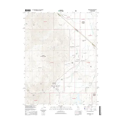
2015 Map of Woodfords
USGS Topo · Published 2015About this map
Woodfords and Alpine Village anchor this landscape where the high peaks of the Toiyabe National Forest meet the productive lands of the Carson Valley. The terrain is defined by a series of steep canyons including Jobs Canyon and West Carson Canyon, which channel water down toward a complex network of historic irrigation features. Water rights and management are central to the area's development, evidenced by the numerous named waterways such as the Snowshoe Thompson Ditch Number Two, Fredericksburg Ditch, and Millich Ditch. These systems parallel the W Fork Carson River to support the lower-elevation settlements of Paynesville and Fredericksburg. Historical transit is marked by the presence of the Emigrant Trl and Old CA-88, tracing the long-standing corridors through the mountains at the California-Nevada border. Local history is further preserved at the Washoe Cemetery near the valley floor.
Find a feature on this map
63 named features on this map. Tap any name to fly to it.
Don’t see what you’re looking for? This feature index may not catch every label — zoom into the map to look around manually.
Map Details
Editions of this 2015 Woodfords Map
This is the sole edition of this map. No revisions or reprints were ever made.
Other maps of this area

1889 · Markleeville
USGS Topo · 1:125,000

1891 · Markleeville
USGS Topo · 1:125,000

1893 · Markleeville
USGS Topo · 1:125,000

1948 · Walker Lake
USGS Topo · 1:250,000
1955 · Freel Peak
USGS Topo · 1:24,000

1955 · Bijou
USGS Topo · 1:24,000

1956 · Freel Peak
USGS Topo · 1:62,500

1956 · Topaz Lake
USGS Topo · 1:62,500

1956 · Markleeville
USGS Topo · 1:62,500

1957 · Walker Lake
USGS Topo · 1:250,000