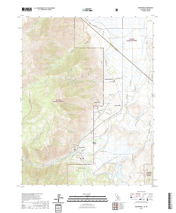
2021 Map of Woodfords
USGS Topo · Published 2021About this map
Woodfords and Fredericksburg anchor this transition from the floor of the Carson Valley to the steep eastern escarpment of the Sierra Nevada. This map records a landscape deeply influenced by historical water management and early travel routes, featuring an intricate network of irrigation channels like the Snowshoe Thompson Ditch Number Two and Millich Ditch that transformed the arid valleys into agricultural lands. For genealogists and local historians, the sheet is particularly valuable for its documentation of burial sites, including the Old Woodfords Cem, Fredericksburg Cem, and Washoe Cem. The terrain is defined by dramatic elevation changes, rising from the residential clusters at Alpine Village and Mesa Vista toward prominent heights such as Jobs Peak and Cary Peak. Numerous named canyons, including Larson Canyon and Cloudburst Canyon, cut through the Toiyabe National Forest, while the W Fork Carson River winds across the valley floor.
Find a feature on this map
75 named features on this map. Tap any name to fly to it.
Don’t see what you’re looking for? This feature index may not catch every label — zoom into the map to look around manually.
Map Details
Editions of this 2021 Woodfords Map
This is the sole edition of this map. No revisions or reprints were ever made.
Other maps of this area

1889 · Markleeville
USGS Topo · 1:125,000

1891 · Markleeville
USGS Topo · 1:125,000

1893 · Markleeville
USGS Topo · 1:125,000

1948 · Walker Lake
USGS Topo · 1:250,000
1955 · Freel Peak
USGS Topo · 1:24,000

1955 · Bijou
USGS Topo · 1:24,000

1956 · Freel Peak
USGS Topo · 1:62,500

1956 · Topaz Lake
USGS Topo · 1:62,500

1956 · Markleeville
USGS Topo · 1:62,500

1957 · Walker Lake
USGS Topo · 1:250,000