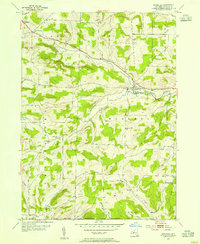
1953 Map of Woodhull
USGS Topo · Published 1967About this map
Tuscarora Creek carves a path through the southern tier of Steuben County, anchoring a landscape defined by small valley settlements and high ridges at the mid-century. The Liberty Highway serves as the primary artery connecting Jasper and Woodhull, passing through the rural crossroads of Five Corners. This period reflects a transition in rural education, as numerous local schoolhouses such as Lyons Sch, Bebout Sch, and Pulteney Hill Sch appear throughout the township, marking a era before the consolidation of these district centers.
Find a feature on this map
32 named features on this map. Tap any name to fly to it.
Don’t see what you’re looking for? This feature index may not catch every label — zoom into the map to look around manually.
Map Details
Editions of this 1953 Woodhull Map
2 editions found
Other maps of this area

1899 · Gaines
USGS Topo · 1:62,500

1900 · Gaines
USGS Topo · 1:62,500

1900 · Elkland
USGS Topo · 1:62,500

1924 · Woodhull
USGS Topo · 1:48,000

1926 · Woodhull
USGS Topo · 1:62,500

1926 · Greenwood
USGS Topo · 1:62,500

1944 · Woodhull
USGS Topo · 1:62,500

1950 · Elmira
USGS Topo · 1:250,000

1953 · Cameron
USGS Topo · 1:24,000

1953 · Woodhull
USGS Topo · 1:24,000