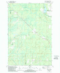
1989 Map of Woodlawn
USGS Topo · Published 1989About this map
The Escanaba River State Forest dominates this landscape on the border of Delta, Marquette, and Menominee counties. This 1989 record captures the Upper Peninsula's interior during a period of managed timberland and hydroelectric infrastructure. The Escanaba River winds through the northern reach, featuring the Boney Falls Basin and the Boney Falls Dam, which includes an adjacent campground and the Bultons Lake area.
Find a feature on this map
23 named features on this map. Tap any name to fly to it.
Don’t see what you’re looking for? This feature index may not catch every label — zoom into the map to look around manually.
Map Details
Editions of this 1989 Woodlawn Map
This is the sole edition of this map. No revisions or reprints were ever made.
Other maps of this area

1932 · Rock SW
USGS Topo · 1:31,680

1932 · Whitney NE
USGS Topo · 1:31,680

1932 · Whitney SE
USGS Topo · 1:31,680

1932 · Helena SW
USGS Topo · 1:31,680

1932 · Gladstone SW
USGS Topo · 1:31,680

1932 · Helena
USGS Topo · 1:31,680

1932 · Gladstone NW
USGS Topo · 1:31,680

1950 · Gladstone NW
USGS Topo · 1:31,680

1951 · Helena SW
USGS Topo · 1:31,680

1951 · Helena
USGS Topo · 1:31,680