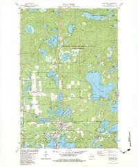
1982 Map of Woodruff
USGS Topo · Published 1983About this map
Woodruff and Minocqua serve as the primary hubs in this lake-studded landscape of northern Wisconsin. The region is defined by its extensive water bodies, including Big Arbor Vitae Lake and Kawaguesaga Lake, which are linked by the Minocqua Thoroughfare. Much of the northern terrain is managed as part of the Northern Highland-American Legion State Forest, highlighting the area's transition toward recreation and conservation. Local infrastructure is well-established, with the Lakeland Municipal Airport and the Milwaukee Road railroad corridor facilitating regional access. For genealogists, the map identifies local landmarks such as Trinity Ch, Woodruff Sch, and Forest Garden Cem. The presence of several Gravel Pits and a Sandpit among the forests and marshes points to the local extraction industries that supported the development of town roads like Towanda Road and Vandercook Road.
Find a feature on this map
100 named features on this map. Tap any name to fly to it.
Don’t see what you’re looking for? This feature index may not catch every label — zoom into the map to look around manually.
Map Details
Editions of this 1982 Woodruff Map
This is the sole edition of this map. No revisions or reprints were ever made.
Other maps of this area

1938 · Minocqua
USGS Topo · 1:48,000

1938 · Lac Du Flambeau
USGS Topo · 1:48,000

1939 · Trout Lake
USGS Topo · 1:48,000

1939 · Lac Du Flambeau
USGS Topo · 1:48,000

1939 · Winchester
USGS Topo · 1:48,000

1946 · Winchester
USGS Topo · 1:48,000

1946 · Minocqua
USGS Topo · 1:48,000

1946 · Lac Du Flambeau
USGS Topo · 1:48,000

1946 · Trout Lake
USGS Topo · 1:48,000

1949 · Trout Lake
USGS Topo · 1:48,000