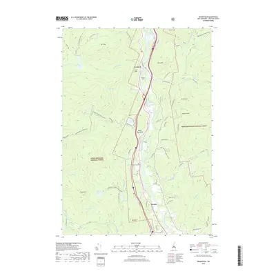
2018 Map of Woodstock
USGS Topo · Published 2018About this map
The Pemigewasset River corridor serves as the primary axis for human settlement in this part of the White Mountains, anchoring the communities of Woodstock, West Thornton, and Thornton. The landscape is defined by the sharp contrast between the developed river valley and the surrounding high country of the White Mountain National Forest. Upland terrain is marked by significant peaks and ridges, including Barron Mtn and Mt Cilley, which are separated by numerous drainages like Hubbard Brook and Glover Brook. Notable local features include Bradley Field and the Pine Grove Cem, alongside water bodies such as Mirror Lake and the remote Elbow Pond. The network of forest roads and snowmobile trails, such as the Mt Cilley Snowo, indicates a modern landscape managed for both timber and recreation, preserving the rugged character of Peaked Hill and the Mill Brook Cascade.
Find a feature on this map
69 named features on this map. Tap any name to fly to it.
Don’t see what you’re looking for? This feature index may not catch every label — zoom into the map to look around manually.
Map Details
Editions of this 2018 Woodstock Map
This is the sole edition of this map. No revisions or reprints were ever made.
Other maps of this area

1928 · Plymouth
USGS Topo · 1:62,500

1928 · Rumney
USGS Topo · 1:62,500

1929 · Moosilauke
USGS Topo · 1:62,500

1929 · Franconia
USGS Topo · 1:62,500

1931 · Plymouth
USGS Topo · 1:62,500

1932 · Franconia
USGS Topo · 1:62,500

1932 · Rumney
USGS Topo · 1:62,500

1932 · Moosilauke
USGS Topo · 1:62,500

1949 · Portland
USGS Topo · 1:250,000

1950 · Lewiston
USGS Topo · 1:250,000