
1973 Map of Worcester South
USGS Topo · Published 1978About this map
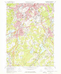
Holy Cross College and Clark University anchor the northern landscape of this region during the 1970s, a period of established institutional presence and suburban expansion south of Worcester. The map reveals a dense network of local-history landmarks, particularly concentrated burial grounds like St Johns Cemetery, Hope Cemetery, and the Notre Dame Cemetery near Curtis Pond. This area is characterized by a complex hydraulic landscape where Kettle Brook feeds into numerous industrial reservoirs and natural bodies such as Singletary Pond and the Stoneville Reservoir. The path of the Massachusetts Turnpike and the Penn Central rail lines illustrate the transportation infrastructure connecting Auburn and Millbury to the urban core. Further south, the terrain transitions into the more open spaces of Sutton and the Merrill Pond State Reservation, where the Oxford Airport and family-named landmarks like Potter Hill and Grass Hill mark the rural-suburban fringe.
Find a feature on this map
105 named features on this map. Tap any name to fly to it.
Don’t see what you’re looking for? This feature index may not catch every label — zoom into the map to look around manually.
Map Details
Editions of this 1973 Worcester South Map
2 editions found
Other maps of this area

1885 · Worcester
USGS Topo · 1:62,500

1886 · Worcester
USGS Topo · 1:62,500

1886 · Blackstone
USGS Topo · 1:62,500

1887 · Marlboro
USGS Topo · 1:62,500

1889 · Marlboro
USGS Topo · 1:62,500

1889 · Blackstone
USGS Topo · 1:62,500

1889 · Webster
USGS Topo · 1:62,500

1892 · Webster
USGS Topo · 1:62,500

1892 · Worcester
USGS Topo · 1:62,500

1893 · Blackstone
USGS Topo · 1:62,500