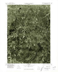
1975 Map of Worcester South
USGS Topo · Published 1981About this map
The industrial corridor south of Worcester is captured in this orthophotomap during the mid-1970s, revealing the dense urban sprawl transitioning into the wooded hills of Worcester County. The Blackstone River and Middle River define the valley’s historical industrial backbone, as the imagery shows the complex intersection of interstate highways and rail lines that replaced earlier canal and mill infrastructure. Commercial and residential development is concentrated around Auburn and the northern reach of Oxford, while the surrounding landscape retains pockets of deep forest and water bodies like Dark Brook Reservoir. Smaller historic nodes like Bramanville and Millbury remain distinct within the growing metropolitan footprint, offering a detailed look at the region’s mid-century suburbanization and its relationship to the older river-town settlements of West Auburn.
Find a feature on this map
9 named features on this map. Tap any name to fly to it.
Don’t see what you’re looking for? This feature index may not catch every label — zoom into the map to look around manually.
Map Details
Editions of this 1975 Worcester South Map
This is the sole edition of this map. No revisions or reprints were ever made.
Other maps of this area

1885 · Worcester
USGS Topo · 1:62,500

1886 · Worcester
USGS Topo · 1:62,500

1886 · Blackstone
USGS Topo · 1:62,500

1887 · Marlboro
USGS Topo · 1:62,500

1889 · Marlboro
USGS Topo · 1:62,500

1889 · Blackstone
USGS Topo · 1:62,500

1889 · Webster
USGS Topo · 1:62,500

1892 · Webster
USGS Topo · 1:62,500

1892 · Worcester
USGS Topo · 1:62,500

1893 · Blackstone
USGS Topo · 1:62,500