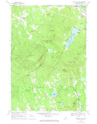
1967 Map of Worthley Pond
USGS Topo · Published 1970About this map
Worthley Pond serves as a central landmark in this 1960s survey of Oxford County, surrounded by the steep elevations of Tumbledown Dick Mtn and Black Mountain. The landscape is defined by the sharp transition between the upland peaks and the winding river valleys, where the Maine Central railroad corridor follows the Androscoggin River through East Peru. Small interior settlements like Dickvale and Sumner are connected by a network of rural routes, including Spears Trail and Russell Trail, illustrating the mid-century transportation patterns of this interior region.
Find a feature on this map
44 named features on this map. Tap any name to fly to it.
Don’t see what you’re looking for? This feature index may not catch every label — zoom into the map to look around manually.
Map Details
Editions of this 1967 Worthley Pond Map
This is the sole edition of this map. No revisions or reprints were ever made.
Other maps of this area

1911 · Bryant Pond
USGS Topo · 1:62,500

1911 · Buckfield
USGS Topo · 1:62,500

1913 · Buckfield
USGS Topo · 1:62,500

1914 · Bryant Pond
USGS Topo · 1:62,500

1926 · Dixfield
USGS Topo · 1:62,500

1927 · Rumford
USGS Topo · 1:48,000

1929 · Dixfield
USGS Topo · 1:62,500

1930 · Rumford
USGS Topo · 1:62,500

1942 · Buckfield
USGS Topo · 1:62,500

1942 · Bryant Pond
USGS Topo · 1:62,500