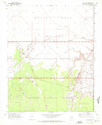
1969 Map of Wupatki SW
USGS Topo · Published 1972About this map
Ancient ancestral sites and volcanic formations define this landscape within the Wupatki National Monument and Coconino National Forest. The map documents a high concentration of archeological remains, including the prominent Citadel and Citadel Ruin, alongside the Lomaki Ruin and Nalakihu Ruin near the edge of Box Canyon. These locations signify the deep history of settlement in the high desert of the Colorado Plateau.
Find a feature on this map
42 named features on this map. Tap any name to fly to it.
Don’t see what you’re looking for? This feature index may not catch every label — zoom into the map to look around manually.
Map Details
Editions of this 1969 Wupatki SW Map
This is the sole edition of this map. No revisions or reprints were ever made.
Other maps of this area

1886 · San Francisco Mtns
USGS Topo · 1:250,000

1891 · San Francisco Mtns
USGS Topo · 1:250,000

1894 · San Francisco Mtns
USGS Topo · 1:250,000

1899 · San Francisco Mtns
USGS Topo · 1:250,000

1908 · Flagstaff
USGS Topo · 1:125,000

1912 · Flagstaff
USGS Topo · 1:125,000

1947 · Flagstaff
USGS Topo · 1:250,000

1954 · Flagstaff
USGS Topo · 1:250,000

1955 · Black Falls NE
USGS Topo · 1:24,000

1958 · Flagstaff
USGS Topo · 1:250,000