
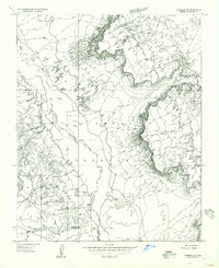
1955 Map of Black Falls NE
USGS Topo · Published 1957About this map
Wupatki National Monument and its ancient history are preserved here at the edge of the Little Colorado River. This mid-century survey captures a transition between the monument's archaeological sites and the expansive Navajo Indian Reservation. Cultural landmarks like the Crack-in-Rock Ruins stand near the river's winding path, illustrating the area's deep human history. The landscape is defined by stark geological formations, from the prominent Black Point to the rising elevations of Ward Terrace in the northeast. Small-scale human presence is noted at the Riveredge settlement and a single Hogan, providing researchers with a look at the sparse inhabited points within the Desert environment during the 1950s. The map also traces the Indian Reservation Boundary as it follows the riverbed, reflecting the intersection of federal and tribal lands.
Find a feature on this map
14 named features on this map. Tap any name to fly to it.
Don’t see what you’re looking for? This feature index may not catch every label — zoom into the map to look around manually.
Map Details
Editions of this 1955 Black Falls NE Map
This is the sole edition of this map. No revisions or reprints were ever made.
Other maps of this area

1886 · San Francisco Mtns
USGS Topo · 1:250,000

1891 · San Francisco Mtns
USGS Topo · 1:250,000

1894 · San Francisco Mtns
USGS Topo · 1:250,000

1899 · San Francisco Mtns
USGS Topo · 1:250,000

1947 · Flagstaff
USGS Topo · 1:250,000

1954 · Flagstaff
USGS Topo · 1:250,000

1955 · Black Falls 4 SW
USGS Topo · 1:24,000

1955 · Cameron SW
USGS Topo · 1:24,000
1955 · Cameron SE
USGS Topo · 1:24,000

1955 · Cameron
USGS Topo · 1:62,500