2023 Map of Wurtsboro
USGS Topo · Published 2023About this map
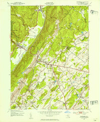
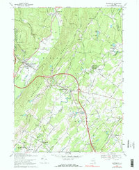
The Shawangunk Mountains anchor this landscape, dividing the watersheds of the Basher Kill and the Shawangunk Kill. In the western valley, the village of Wurtsboro sits alongside the historic Delaware and Hudson Canal, a corridor that once powered the regional economy. The eastern slopes are characterized by numerous small settlements and family-named landmarks, reflecting a deep-seated rural character. Genealogists can find significant local records through the Chester Stanton Memorial Cem, Sylvan Cem, and the Temple Sinai Cem near Fair Oaks.
Find a feature on this map
170 named features on this map. Tap any name to fly to it.
Don’t see what you’re looking for? This feature index may not catch every label — zoom into the map to look around manually.
Map Details
Editions of this 2023 Wurtsboro Map
This is the sole edition of this map. No revisions or reprints were ever made.
Historical Maps of Wurtsboro Through Time
3 maps found