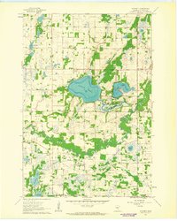
1961 Map of Wyanett
USGS Topo · Published 1963About this map
The Rum River winds through this central Minnesota landscape, characterized by a dense concentration of glacial lakes and wetlands in the early 1960s. The settlement of Wyanett and the nearby Old Wyanett Free Cem reflect the rural community structure of Isanti County, while the Spectacle Lake Wildlife Management Area preserves a significant portion of the local ecosystem. Further south, the Spencer Brook waterway defines the southern portion of the map, supporting small clusters of activity near Pine Brook and West Point.
Find a feature on this map
31 named features on this map. Tap any name to fly to it.
Don’t see what you’re looking for? This feature index may not catch every label — zoom into the map to look around manually.
Map Details
Editions of this 1961 Wyanett Map
2 editions found
Other maps of this area

1916 · St. Francis
USGS Topo · 1:62,500

1919 · St. Francis
USGS Topo · 1:62,500

1953 · Stillwater
USGS Topo · 1:250,000

1955 · Stillwater
USGS Topo · 1:250,000

1958 · Stillwater
USGS Topo · 1:250,000

1961 · Bradford
USGS Topo · 1:24,000

1961 · Lake Fremont
USGS Topo · 1:24,000

1961 · Springvale
USGS Topo · 1:24,000

1961 · Dalbo
USGS Topo · 1:24,000

1961 · Wyanett
USGS Topo · 1:24,000