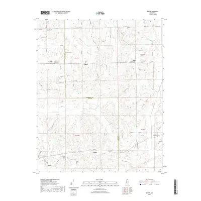
2018 Map of Wyatte
USGS Topo · Published 2018About this map
Wyatte and Chulahoma anchor the rural landscape of this Northern Mississippi border region, where the boundary between Tate Co and Marshall Co cuts through the rolling hills. The settlement pattern is defined by scattered family-named locations and small communities like Wakefield and Wallhill, connected by a network of winding roads such as Tyro Rd and Wyatte Loop. The terrain is deeply carved by water systems, including Hickahala Cr and Cuffawa Creek, which drain the numerous small coves and ridges like Hideaway Hill.
Find a feature on this map
80 named features on this map. Tap any name to fly to it.
Don’t see what you’re looking for? This feature index may not catch every label — zoom into the map to look around manually.
Map Details
Editions of this 2018 Wyatte Map
This is the sole edition of this map. No revisions or reprints were ever made.
Other maps of this area

1944 · Senatobia
USGS Topo · 1:62,500

1944 · Hernando
USGS Topo · 1:62,500

1944 · Tyro
USGS Topo · 1:62,500

1948 · Byhalia
USGS Topo · 1:62,500

1956 · Tupelo
USGS Topo · 1:250,000

1958 · Tupelo
USGS Topo · 1:250,000
1971 · Byhalia
USGS Topo · 1:24,000
1971 · Marianna
USGS Topo · 1:24,000

1971 · Wyatte
USGS Topo · 1:24,000

1971 · Laws Hill
USGS Topo · 1:24,000