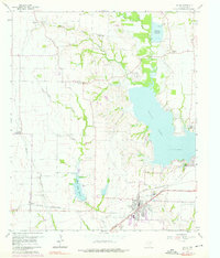
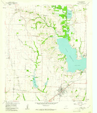
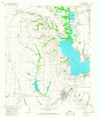
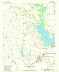
1959 Map of Wylie
USGS Topo · Published 1976About this map
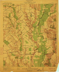
The waters of Lavon Lake dominate the eastern landscape of this area, while the St Louis Southwestern and Atchison Topeka and Santa Fe railroads converge at the growing town of Wylie. This mid-century survey captures a period of transition as local infrastructure expanded with the construction of an aqueduct, a Filtration Plant, and a Radio Range Station. Beyond the town centers, the map documents a network of rural communities such as Murphy, Lucas, and Parker, each anchored by generational landmarks like the Fitzhugh Cem and St Paul Ch. The presence of several gravel pits and the Muddy Creek Reservoir reflects the industrial and water management needs of Collin County before the major suburban expansions of the late 20th century.
Find a feature on this map
44 named features on this map. Tap any name to fly to it.
Don’t see what you’re looking for? This feature index may not catch every label — zoom into the map to look around manually.
Map Details
Editions of this 1959 Wylie Map
4 editions found
Other maps of this area

1891 · Dallas
USGS Topo · 1:125,000

1893 · Dallas
USGS Topo · 1:125,000
1912 · Rockwall
USGS Topo · 1:31,680

1919 · Royse City
USGS Topo · 1:62,500

1924 · Farmersville 3-c
USGS Topo · 1:48,000

1924 · Mc Kinney 4-d
USGS Topo · 1:48,000

1929 · McKinney
USGS Topo · 1:62,500

1930 · Farmersville
USGS Topo · 1:62,500

1954 · Dallas
USGS Topo · 1:250,000

1954 · Sherman
USGS Topo · 1:250,000