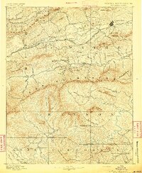
1889 Map of Wytheville
USGS Topo · Published 1892About this map
Wytheville serves as the prominent rail and transit hub of this late-19th-century survey, situated along the Norfolk and Western Railroad corridor. The landscape is defined by the high ridges of the Iron Mountains and Walker Mountain, which separate the pastoral valleys of the Middle Fork Holston River from the rugged terrain to the south. The industrial heritage of the Blue Ridge is evident through the presence of ironworks like White Rock Furnace and Speedwell Furnace, which utilized local timber and ore.
Find a feature on this map
115 named features on this map. Tap any name to fly to it.
Don’t see what you’re looking for? This feature index may not catch every label — zoom into the map to look around manually.
Map Details
Editions of this 1889 Wytheville Map
2 editions found
Other maps of this area

1887 · Pocahontas
USGS Topo · 1:125,000

1889 · Hillsville
USGS Topo · 1:125,000

1889 · Wytheville
USGS Topo · 1:125,000

1889 · Wilkesboro
USGS Topo · 1:125,000

1890 · Dublin
USGS Topo · 1:125,000

1891 · Tazewell
USGS Topo · 1:125,000

1891 · Pocahontas
USGS Topo · 1:125,000

1891 · Dublin
USGS Topo · 1:125,000

1891 · Abingdon
USGS Topo · 1:125,000

1891 · Wilkesboro
USGS Topo · 1:125,000