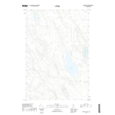
2018 Map of Wytopitlock Lake
USGS Topo · Published 2018About this map
Wytopitlock Lake and the surrounding wetlands of Aroostook County dominate this interior Maine landscape, defined by a complex network of glacial hydrology. The terrain is characterized by winding watercourses such as Wytopitlock Stream and Macwahoc Stream, which drain into stagnant basins like the Thompson Deadwater. Human activity is sparse, concentrated primarily along a few established thoroughfares like Lake Rd and Dixie Rd. For local historians and genealogists, the Pierce Cem near the junction of these roads provides a rare permanent marker of the families who settled this timber-and-water territory. Isolated water bodies like Duck Pond, Braley Lake, and the remote Lost Pond dot the high ground between the various brooks, illustrating the primary drainage patterns of the region's wilderness.
Find a feature on this map
15 named features on this map. Tap any name to fly to it.
Don’t see what you’re looking for? This feature index may not catch every label — zoom into the map to look around manually.
Map Details
Editions of this 2018 Wytopitlock Lake Map
This is the sole edition of this map. No revisions or reprints were ever made.
Other maps of this area

1940 · Sherman
USGS Topo · 1:62,500

1940 · Mattawamkeag
USGS Topo · 1:62,500

1941 · Mattawamkeag Lake
USGS Topo · 1:62,500

1941 · Wytopitlock
USGS Topo · 1:62,500

1942 · Mattawamkeag
USGS Topo · 1:62,500

1942 · Sherman
USGS Topo · 1:62,500

1943 · Wytopitlock
USGS Topo · 1:62,500

1943 · Mattawamkeag Lake
USGS Topo · 1:62,500

1954 · Millinocket
USGS Topo · 1:250,000

1958 · Millinocket
USGS Topo · 1:250,000