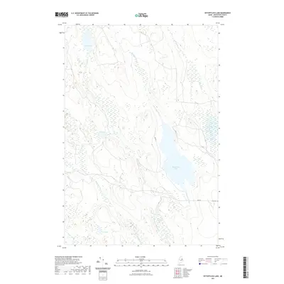
2021 Map of Wytopitlock Lake
USGS Topo · Published 2021About this map
Wytopitlock Lake and its surrounding wetlands define this portion of southern Aroostook County, where complex drainage networks feed into the Wytopitlock Stream and Macwahoc Stream. The landscape is characterized by its glacial hydrology, featuring isolated water bodies like Braley Lake, Duck Pond, and the secluded Lost Pond near Juniper Brook. Human presence is sparse, centered primarily along Lake Rd and Dixie Rd near the eastern shore. Evidence of early settlement history is preserved at the Pierce Cem located along the eastern boundary. The map illustrates a remote timberland environment where traditional logging routes likely followed the natural corridors of the Thompson Deadwater and its connecting brooks.
Find a feature on this map
14 named features on this map. Tap any name to fly to it.
Don’t see what you’re looking for? This feature index may not catch every label — zoom into the map to look around manually.
Map Details
Editions of this 2021 Wytopitlock Lake Map
This is the sole edition of this map. No revisions or reprints were ever made.
Other maps of this area

1940 · Sherman
USGS Topo · 1:62,500

1940 · Mattawamkeag
USGS Topo · 1:62,500

1941 · Mattawamkeag Lake
USGS Topo · 1:62,500

1941 · Wytopitlock
USGS Topo · 1:62,500

1942 · Mattawamkeag
USGS Topo · 1:62,500

1942 · Sherman
USGS Topo · 1:62,500

1943 · Wytopitlock
USGS Topo · 1:62,500

1943 · Mattawamkeag Lake
USGS Topo · 1:62,500

1954 · Millinocket
USGS Topo · 1:250,000

1958 · Millinocket
USGS Topo · 1:250,000