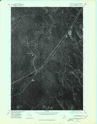
1975 Map of Wytopitlock NW
USGS Topo · Published 1980About this map
Reed sits in a landscape of dense Maine woodland, as documented in this 1975 orthophotoquad. The imagery reveals the winding path of Macwahoc Stream as it meanders through the central and western portions of the quadrangle, contrasted by the straighter industrial or transportation corridors cutting through the forest. To the east, the waters of Wytopitlock Stream and Meadow Brook flow through the timberlands, highlighting the hydrological network that historically defined the region's economy and settlement patterns.
Find a feature on this map
5 named features on this map. Tap any name to fly to it.
Don’t see what you’re looking for? This feature index may not catch every label — zoom into the map to look around manually.
Map Details
Editions of this 1975 Wytopitlock NW Map
This is the sole edition of this map. No revisions or reprints were ever made.
Other maps of this area

1940 · Sherman
USGS Topo · 1:62,500

1940 · Mattawamkeag
USGS Topo · 1:62,500

1941 · Mattawamkeag Lake
USGS Topo · 1:62,500

1941 · Wytopitlock
USGS Topo · 1:62,500

1942 · Mattawamkeag
USGS Topo · 1:62,500

1942 · Sherman
USGS Topo · 1:62,500

1943 · Wytopitlock
USGS Topo · 1:62,500

1943 · Mattawamkeag Lake
USGS Topo · 1:62,500

1954 · Millinocket
USGS Topo · 1:250,000

1958 · Millinocket
USGS Topo · 1:250,000
Featured Places
- Reed, Reed Plantation
- Reed Plantation, ME
- Macwahoc Plantation, ME
- Drew Plantation, ME
- Upper Molunkus Township, ME